
Kings Canyon
The Rim Walk of Watarrka
schedule 3 min read / Updated Jun 2026
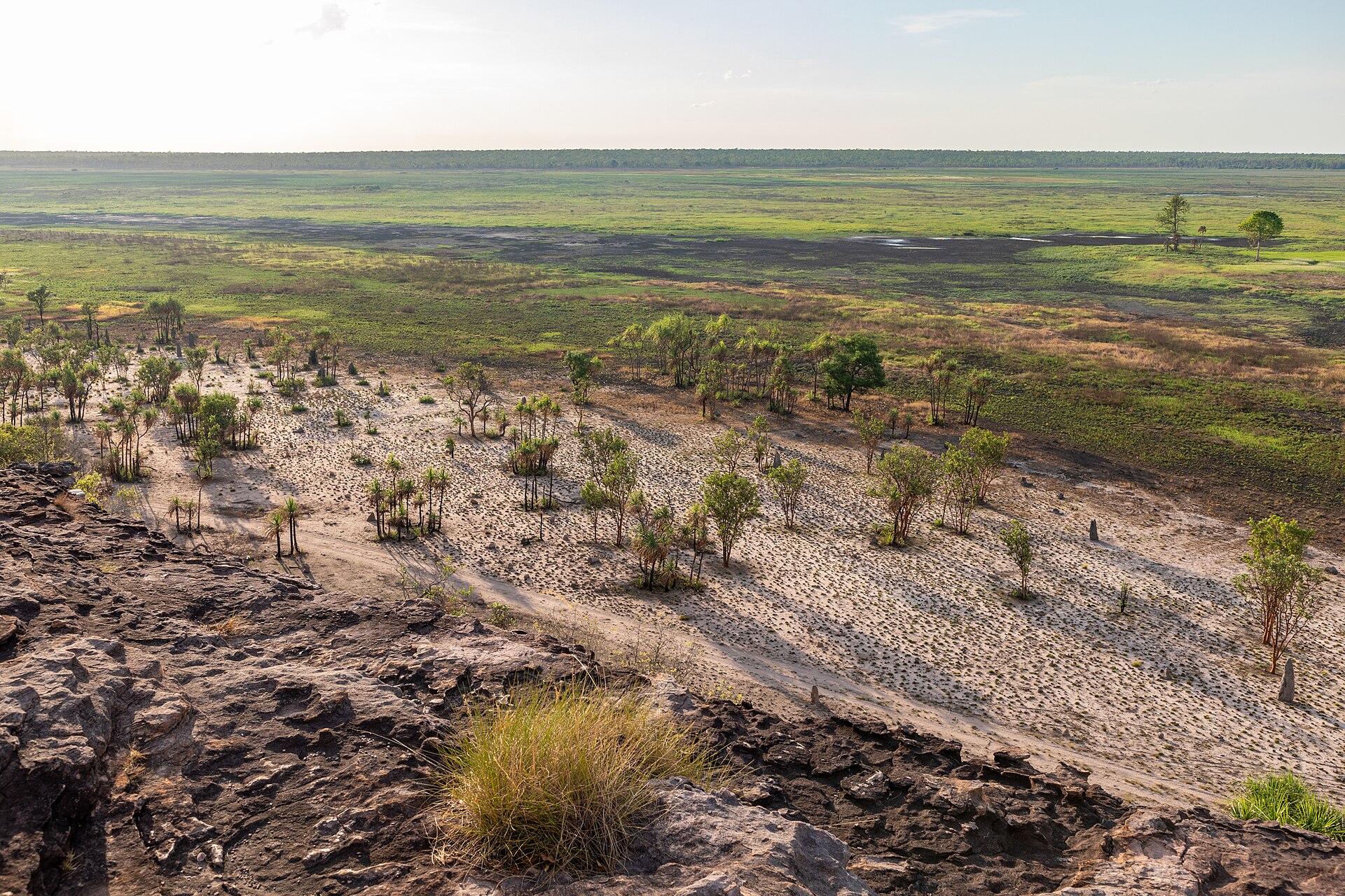
A 270 metre sandstone chasm cut through the George Gill Range in Watarrka National Park, central Australia. The rim walk that circles the top of Kings Canyon is widely regarded as the single best day hike in the Red Centre.
Kings Canyon sits in the heart of Watarrka National Park in the Northern Territory, around 300 kilometres south-west of Alice Springs and about four hours' drive from Uluru. The canyon itself is 270 metres deep and was cut through the George Gill Range by a creek that still runs at the bottom during the wet season and after rare storms. The sandstone cliffs on both sides are made of Mereenie sandstone, laid down 440 million years ago as beach sand and now some of the oldest exposed rock in central Australia.
The traditional owners of Watarrka are the Luritja people, who have lived in this country for at least 20,000 years. Luritja stories explain the major landscape features of the canyon and the surrounding range, and several areas of the canyon are sacred and restricted. The park is jointly managed with traditional owners under a framework similar to Uluru-Kata Tjuta, and ranger-led cultural talks and interpretive signs draw on Luritja knowledge.
The Rim Walk is the reason most visitors come. The 6 kilometre circular track starts with a short but steep climb called Heart Attack Hill, which gains 150 metres of elevation in about 500 metres of walking. Once at the top, the track circles the rim of the canyon for about two hours, passing a variety of weathered sandstone domes that the early European explorers named the Lost City. Halfway around, a short side track descends into the Garden of Eden, a permanent waterhole at the head of the canyon surrounded by cycads and ferns that are direct descendants of plants from 300 million years ago.
The views from the south rim back across the canyon to the north rim are among the most photographed in central Australia, particularly in the early morning when the low sun lights the red sandstone walls from the side. The track returns to the car park via the far side of the rim, passing more domes and offering a different angle on the canyon itself before descending back to the creek bed.
A shorter option is the Kings Creek Walk, which follows the bottom of the canyon for around one kilometre to a lookout at the base of the cliffs. This walk is fully accessible as far as the first lookout and takes about an hour return. It is the only way to see the canyon from below and is recommended as a supplement to the Rim Walk rather than an alternative.
Kings Canyon Resort and Kings Creek Station are the two accommodation options within easy reach of the canyon. The resort is six kilometres from the canyon itself and has hotel rooms, backpacker lodges and a campground. Kings Creek Station, 30 minutes further out, is a working camel and cattle station with glamping tents and a famous cafe that serves camel burgers. Visitors on the classic central Australia loop typically do Uluru, Kings Canyon and Alice Springs over five to seven days.
The Rim Walk is closed when forecast temperatures exceed 36 degrees, which happens regularly between October and March. The Northern Territory Parks and Wildlife service enforces this rule at 9am, so early starts are essential even in the winter months. The best time to visit is May to September, when daytime temperatures are mild and the early mornings are cold and clear. Sunrise at the canyon rim is legendary and is the single highest-impact experience on the classic Red Centre circuit.
Common questions
Things visitors ask about Kings Canyon.
Quick answers to help you plan.
Where is Kings Canyon?
expand_more
Kings Canyon sits within Watarrka National Park in the southern Northern Territory, at the western end of the George Gill Range. The canyon walls rise about 100 metres above Kings Creek to a sandstone plateau dotted with weathered domes. The park is jointly managed by the Northern Territory Government and the Luritja Traditional Owners.
How far is Kings Canyon from Uluru?
expand_more
Kings Canyon is roughly 300km north-east of Uluru by sealed road, a drive of about 3.5 to 4 hours. The route runs along the Lasseter Highway and then north on Luritja Road, and a regular two-wheel-drive car handles it comfortably. Most travellers visit Uluru and Kings Canyon as part of the same Red Centre loop.
How far is Kings Canyon from Alice Springs?
expand_more
NT Parks lists Watarrka National Park as 450km south-west of Alice Springs. Via the sealed Stuart and Lasseter highways the drive is about 5 to 6 hours. The shorter inland route via the Mereenie Loop Road is about 332km but is partly unsealed.
Should I drive the Mereenie Loop Road or the Lasseter Highway?
expand_more
The Lasseter Highway route is fully sealed and suits any vehicle, but it is longer because it loops south through Erldunda. The Mereenie Loop is shorter and far more scenic, with about 140km of unsealed dirt that has corrugations, washouts and loose gravel, so a 4WD is recommended. The Mereenie Loop also crosses Aboriginal land, so you need a transit permit (around $5 to $6) available from Alice Springs Visitor Information Centre, Kings Canyon Resort and other outlets.
What is the Kings Canyon Rim Walk like?
expand_more
The Rim Walk is a 6km loop that takes 3 to 4 hours and is rated Grade 4. It begins with a steep climb (locally nicknamed Heart Attack Hill) up to the canyon edge, then traces the rim past the Lost City sandstone domes and down into the Garden of Eden waterhole before returning. NT Parks recommends it only for fit, healthy walkers.
Is there an easier walk than the Rim Walk?
expand_more
Yes, the Kings Creek Walk is a 2.6km return track along the canyon floor that takes about an hour and is rated Grade 2 (easy). It follows the creek bed through river red gums to a viewing platform looking up at the canyon walls. Kathleen Springs, 21km away by road, offers a fully sealed 2.4km wheelchair-accessible track to a spring-fed waterhole.
What are the Garden of Eden and the Lost City?
expand_more
The Lost City is a cluster of weathered sandstone domes on the canyon plateau, encountered roughly halfway around the Rim Walk. The Garden of Eden is a permanent waterhole tucked into a sheltered side gorge, fed by springs and shaded by ancient MacDonnell Ranges Cycads. Swimming in the Garden of Eden is not permitted because the waterhole is culturally significant.
When does the Rim Walk close due to heat?
expand_more
On any day when the forecast maximum is 36C or above, the gate closes at 9am and you will not be allowed to start the Rim Walk after that time. The South Wall Return walk has the same 36C rule but a slightly later 11am cut-off. In the warmer months most walkers start before sunrise to beat both the heat and the gate.
Do I need to pay to enter Watarrka National Park?
expand_more
Yes. Interstate and international visitors need an NT Parks Pass, which costs $10 adult, $5 child or $25 family for a single day, or $30, $15, $75 for two weeks (current NT Parks rates). NT residents are exempt but may be asked to show proof of residency. Camping and certain walking fees are charged separately.
Where can I stay near Kings Canyon?
expand_more
Discovery Resorts Kings Canyon (formerly Kings Canyon Resort) sits 7km from the park entrance and offers hotel rooms, glamping tents and powered/unpowered campsites. Kings Creek Station, a working cattle station 36km from the canyon, has bush tents, premium safari tents and a campground. Camping inside the national park itself is not permitted.
When is the best time of year to visit Kings Canyon?
expand_more
The cooler dry season from April to September is the most pleasant, with mild days, cold nights and clear skies. Access is restricted between September and March because of extreme heat, with regular gate closures on the Rim Walk. May to August is the sweet spot for hiking and photography.
Whose Country is Watarrka?
expand_more
Watarrka is the Country of the Luritja people, who have lived in the area for tens of thousands of years (some sources also recognise Arrernte connections). The name "watarrka" is the Luritja word for the umbrella bush (Acacia ligulata) that grows around the canyon. The park is jointly managed by the Traditional Owners and the NT Government.
When is the best time of day to photograph the canyon?
expand_more
Sunrise is the standout, when low light hits the eastern-facing sandstone domes and turns them deep orange and red. Photographers typically reach the trailhead about an hour before sunrise so they can be on the rim as the first light lands. Late afternoon also works well from the lower Kings Creek Walk, which sits in shadow once the sun drops behind the south wall.
Tourist locations
Places to visit in Kings Canyon.
6 locations to explore
Garden of Eden - Kings Canyon
Hidden oasis on the rim
$10 adult day pass (NT Parks Visitor Pass required, accessed via Rim Walk)
Full guide arrow_forwardKathleen Springs Walk
Sealed path to a desert spring
$10 adult day pass (NT Parks Visitor Pass required)
Full guide arrow_forwardKings Canyon Rim Walk
Red Centre's iconic canyon circuit
$10 adult day pass (NT Parks Visitor Pass required)
Full guide arrow_forwardKings Canyon Scenic Helicopter Flights
Canyon views from above
From $145 per person (8-minute Canyon Dash)
Full guide arrow_forwardKings Creek Station - Outback Tours and Cultural Experiences
Working station, Red Centre soul
Buggy Station Tour from $475 per group; Karrke Cultural Experience see website for pricing
Full guide arrow_forwardKings Creek Walk
Easy canyon floor stroll
$10 adult day pass (NT Parks Visitor Pass required)
Full guide arrow_forwardGallery
Kings Canyon in pictures.
11 images licensed from Wikimedia Commons
All images are sourced from Wikimedia Commons under Creative Commons licences. Individual photographers are credited on the source pages.
On the itinerary
Trip plans that include Kings Canyon.

From the journal
Read more about Kings Canyon.

Guide · 4 min read
Outback Safety
Every year visitors die in the Australian outback because they underestimate distance, heat and remoteness. Here is what to do to not become a statistic.

Guide · 4 min read
The Best Time to Visit Australia
Australia is too big for a single 'best time'. The right month depends entirely on where you are going and what you want to see. Here is the full calendar.

Guide · 2 min read
Weather and When to Go
Australia spans almost 4,000 kilometres north to south, from the tropics to the temperate cool. The right season for one half of the country is the wrong one for the other.
Scenic views
Lookouts near Kings Canyon.
You may also like

Watarrka National Park

Mount Conner (Atila)
Ubirr

Mary River National Park

Mataranka

Standley Chasm

Gunlom Falls

Kakadu National Park

Alice Springs

Mindil Beach

Katherine Gorge (Nitmiluk)

Uluru & Kata Tjuta
Attribution
Sources & credits
Content (5)
- Wikipedia: Kings Canyon · CC BY-SA 4.0
- Watarrka National Park · Northern Territory Government
- Short walks in Watarrka National Park · Northern Territory Government
- NT Parks Visitor Pass · Northern Territory Government
- Kings Canyon and Watarrka National Park · Tourism NT
Images (11)
- Hooded Robin female 0A2A5956.jpg · JJ Harrison · CC BY-SA 3.0
- Kings Canyon Gorge.jpg · Albinfo · Public domain
- Kings Canyon NT view.jpg · Zoharby · CC BY-SA 3.0
- Cd watarrka kings canyon.jpg · ChatDaniels · CC BY-SA 3.0
- Coucher de Soleil sur Kings Canyon.jpg · ogwen · CC BY 2.0
- Ghost Gum, Kings Canyon 5305.jpg · PotMart186 · CC BY-SA 4.0
- Kings-Canyon.JPG · Ueli Fahrni · CC BY-SA 3.0
- Kings Canyon.JPG · Alexandra at lb.wikipedia · CC BY-SA 3.0
- Kings Canyon - panoramio (11).jpg · qwesy qwesy · CC BY 3.0
- Kings Canyon Rim Walk.jpg · Teckez · CC BY-SA 4.0
- Kings Canyon Steinabbruch.JPG · Roll-Stone · Public domain
.jpg)
Images sourced from Wikimedia Commons under licenses that permit commercial use. If you are the rights holder and believe an attribution is incorrect, please contact us.